|
LAFOURCHE PARISH GAME AND FISH COMMISSION
Original Lake
Fields Restoration Plan
| |||||||||||||||||||||||||||
|
Background
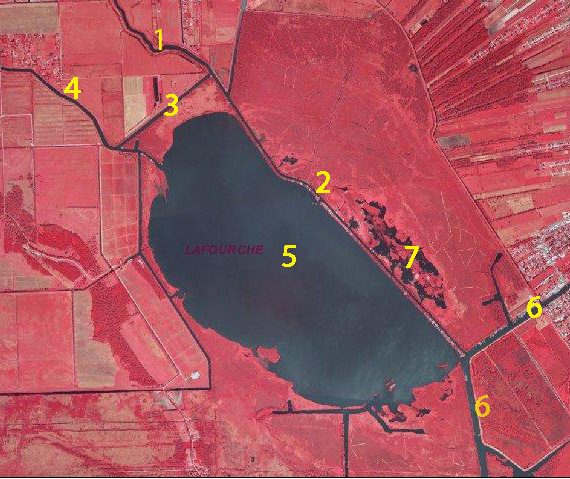
Lake Fields is due west of Lockport, south of U.S. Highway 90, and north of the Gulf Intracoastal Waterway in Lafourche Parish and is approximately 2,000 acres in size. The lake is situated in an inter-levee basin between the Bayou Lafourche natural ridge to the east and the Bayou Grand Coteau ridge to the west. The Lake is surrounded by primarily "flotant" fresh marsh characterized by shallow ponds, open marsh grass areas, and extensive wax myrtle thickets. Bottomland hardwoods occur primarily along canal spoil banks. Major water bodies in the Preserve are identified in the following figure.
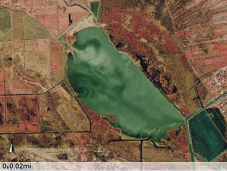
The Lake Fields watershed of 52,214 acres originates just south of Thibodaux. The watershed has been significantly altered but is sparsely populated except for the Bayou Lafourche corridor. The drainage basin is 38.7% agriculture/cropland/grassland, 20% fresh marsh, 18.4% wetland forests, 9.4% urban, and 8.5% water, with the remainder miscellaneous forests or wetlands. Prior to the early 1960s, Lake Fields was known for clear water, profuse submergent vegetation, and excellent sport fish and waterfowl populations. Lake Fields was and remains a very popular recreational site because of the numerous nearby camps and the close proximity to residential areas. However, sport fish and waterfowl populations have declined dramatically in the lake proper in association with declining water quality and physical habitat. The lake is currently characterized by low water clarity, high nutrient levels, periodic algal blooms, and a virtual absence of ecologically important submergent aquatic vegetation. The ecological deterioration of Lake Fields can largely be attributed to major physical modifications in the watershed. During the 1800s, Lake Fields was a semi-isolated freshwater lake with a small and undeveloped watershed and surrounded by continuous fresh marsh and drained by Bayou L’eau Bleu. However, major historical changes in the drainage basin and watershed hydrology eventually significantly increased the inflow of nutrient-laden, degraded water from the upper watershed into Lake Fields. Major watershed modifications occurred in two phases – nearby private land reclamation projects in the early 1900s and an upper Bayou Folse watershed drainage project by the U.S. Department of Agriculture Soil Conservation Service beginning during the late 1960s. As a result of the land reclamation projects, sections of flotant marsh were surrounded by ring levees, drained with interior canals, and flanked by newly dug exterior canals such as Bayou Folse and Bayou Dumar to facilitate movement of water downstream. Upper watershed flow initially largely bypassed Lake Fields and drained into Company Canal, but later physical changes rerouted an increased proportion of flow into Lake Fields. This inflow, which had become increasingly obvious by the 1960s, was associated with several specific physical watershed modifications. The first was the erosion / subsidence of the west bank of lower Bayou Folse and an oil exploration canal, which created openings into Lake Fields. The second was the decrease in water depths of Bayou Folse due to the accumulation of sediments and organic materials. Finally, there were unforeseen, adverse impacts associated with an upper Bayou Folse watershed drainage project beginning during the late-1960s by the U.S. Department of Agriculture Soil Conservation Service. The project included clearing and deepening of upper Bayou Folse, pump stations, diverting water from the 40-arpent canal into Bayou Folse, other drainage improvements, and a substantial increase in watershed drainage area. As a result of these modifications, the flow capacity in upper and mid-Bayou Folse was increased and more turbid, nutrient-enriched water originating from cattle pasture, farm land, and residential area runoff entered the Bayou. However, lower Bayou Folse was shallower than upper Bayou Folse and was unable to accommodate this increased flow capacity; subsequently, an increased proportion of the upper Bayou Folse water flow was diverted through Commercial Canal into Bayou Dumar and eventually into northern Lake Fields. The inflow of degraded water into Lake Fields via Commercial Canal and Bayou Dumar is illustrated below. This degraded water then flowed through the entire lake before exiting through Company Canal at the southeastern corner of Lake Fields.
The increased inflow of nutrient-laden, poor quality water from the upper watershed resulted in immediate and long-term adverse impacts on water quality and physical habitats in Lake Fields and adjacent marshes. Periodic algal blooms and a dramatic decline in submergent aquatic plants occurred as water became more turbid and nutrient enriched. Shoreline erosion also accelerated without the wave-dampening cushion provided by dense growths of submergent and emergent vegetation; eventually the lake rim deteriorated in some areas and exposed the fragile interior wetlands to wave action and tidal processes. Project Plans The Commission is promoting a management plan to restore the Lake Fields ecosystem. The Commission has received input from a number of conservation organizations and governmental institutions including Ducks Unlimited, Barataria-Terrebonne National Estuary Program (BTNEP), Louisiana Department of Wildlife and Fisheries, U.S. National Resources Conservation Service, and the North Lafourche Levee District. The BTNEP Management Conference formally endorsed the management plan at their December, 2008 meeting. The goals of the Lake Fields restoration plan are to: a) improve water quality; b) reduce wave action and shoreline erosion; c) increase emergent and submergent vegetation; and, d) increase habitat diversity. The aforementioned goals will be accomplished through two independent but complimentary projects: a) redirection of water flow; and, b) earthern terraces. Phase I. Redirection of Water Flow The overall objective of this project is to redirect upper watershed runoff around rather than into Lake Fields by facilitating Bayou Dumar and Bayou Folse water flow into lower Bayou Folse and eventually into Company Canal. The reduced input of nutrient laden, degraded water into Lake Fields will improve water quality and stimulate submergent vegetation. The following specific actions are recommended at this point.
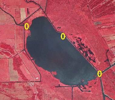
In contrast to earlier attempts to redirect water flow around Lake Fields, the effects of the proposed project should persist. First, the channel constrictions in lower Bayou Dumar and Commercial Canal at its intersection with Bayou Folse will facilitate water flow around Lake Fields. Second, the sufficient deepening of lower Bayou Folse will increase the flow capacity such that the upper watershed flow is accommodated. Finally, the size reduction of the three Lake Fields openings along lower Bayou Folse, Bayou Dumar, and Company Canal will also reduce leakage of degraded water into the Lake. Dredged materials from lower Bayou Folse should be placed to minimize sloughing of materials back into the channel and should be used beneficially, including but not limited to: restricting openings from Bayou Folse or Company Canal into Lake Fields; closing or restricting openings between Bayou Folse and Little Lake; upgrading the eastern bank of Bayou Folse; and, creating emergent marsh sites in Little Lake. Vegetative plantings of appropriate wetland plant species are recommended at sites subjected to high energy wave action. An alternative method of reducing upper drainage basin water flow into Lake Fields may be with the strategic placement of earthern terraces (see next section) adjacent lake openings. Phase II. Earthen Terraces Earthen terraces are a viable marsh restoration tool. Terraces are usually arranged in an alternating pattern at 30-degree angles and placed in a "V" shape (referred to as a "duck wing terrace") so that regardless of the wind direction, calm water will exist on the downwind side of the terrace. Terraces are usually about four times wider at the base than at the top, two feet or more above water level, and planted with native vegetation to reduce erosion. Additionally, marsh creation with earthern terraces is easily quantified and qualifies as a mitigation credit. Priority areas for terrace placement should include the shoreline protecting camps along lower Bayou Folse, shorelines that are subjected to wave action and subsequent erosion associated with seasonal prevailing winds (ie., southeast in spring, summer, and fall and north in winter), and to locations that reduce inflow of water into Lake Fields. For several reasons, the eastern shoreline of Lake Fields should be a high priority: a) two openings into the lake from Company Canal and lower Bayou Folse are included; b) the shoreline is very susceptible to wave-induced erosion from seasonal southeasterly winds; and, c) the west bank of lower Bayou Folse prevents spillover of degraded water into Lake Fields and also protects the many camps. Another high priority location should be lower Bayou Dumar below Commercial Canal. Other high priority locations are adjacent the mouth of Bayou Dumar and the southern lake rim of Lake Field. The Bayou Dumar terraces will reduce water flow into the lake. The southern shoreline has been subjected to severe erosion associated with winter time north winds and the interior marshes have become exposed. There are several terrace placement options that are applicable to Lake Fields: discontinuous terraces perpendicular or angled to the shoreline; continuous terraces on submerged spoil banks or shorelines. Shallow littoral areas on the landward side of the terraces will provide optimum conditions for submergent and emergent vegetation. All terraces should be accompanied by vegetative plantings of appropriate wetland plant species. Benefits The following table summarizes potential benefits from the proposed management plan.
|