|
LAFOURCHE PARISH GAME AND FISH COMMISSION
Lake
Fields Historic Water Flow Restoration
| |||
|
Background
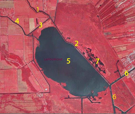
The Lake Fields ecosystem was significantly altered by reclamation projects in the early 1900s and a upper Bayou Folse drainage improvement project by the U. S. Soil Conservation Service beginning in the late 1960s; the original restoration plan provides a more detailed perspective on the decline of Lake Fields and recommendations to restore the Lake. As a result of these modifications, the flow capacity in upper and mid-Bayou Folse was increased and more turbid, nutrient-enriched water originating from cattle pasture, farm land, and residential area runoff entered the Bayou. However, lower Bayou Folse was shallower than upper Bayou Folse and was unable to accommodate this increased flow capacity; subsequently, an increased proportion of the upper Bayou Folse water flow was diverted through Commercial Canal into Bayou Dumar and eventually into northern Lake Fields. Major water bodies pertinent to the hydrological restoration plan are identified below.
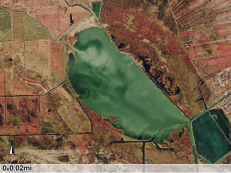
The inflow of degraded water into Lake Fields via Commercial Canal and Bayou Dumar is illustrated below. This degraded water then flowed through the entire lake before exiting through Company Canal at the southeastern corner of Lake Fields.
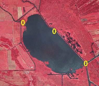
The original Lake Fields restoration plan by the Commission involved two independent but complimentary components: redirection of Bayou Folse water into Company Canal rather than through the Lake, and creation of terraces around the Lake Fields shoreline. The North Lafourche Levee District recently completed a mitigation project in Lake Fields and lower Bayou Folse that was largely based upon the Commission's restoration plan. A major component of the Levee District's project included the dredging of lower Bayou Folse to create shoreline terraces. However, several components of the hydrological restoration plan were not included. Project Plans The overall objective of this project is to further reduce the inflow of degraded, upper Bayou Folse water into Lake Fields. This objective will be accomplished by reducing the width of openings into Lake Fields, including Bayou Dumar, a cut through the lower Bayou Folse ridge, and the opening into Company Canal (see following figure). Bayou Folse, which receives the drainage and runoff from the upper Bayou Folse watershed, splits north of Lake Fields into Bayou Dumar and lower Bayou Folse. The reduced input of nutrient laden, degraded water into Lake Fields will improve water quality and stimulate submergent vegetation.
The strategic placement and arrangement of terraces is the most efficient and economical method of reducing these openings into Lake Fields. Terraces are typically arranged in an alternating pattern at 30-degree angles and placed in a "V" shape (referred to as a "duck wing terrace") or parallel to the shoreline. For these projects, the terraces will be arranged to reduce the openings into Lake Fields to reduce upper drainage system water flow into the lake. Terraces are usually about four times wider at the base than at the top, two feet or more above water level, and planted with native vegetation to reduce erosion. The lower Bayou Dumar opening into Lake Fields is the top priority, followed by the northern cut through the lower Bayou Folse (Camp Canal) ridge and the opening into Company Canal. |